
A Short History of Alresford
Early Times
What is now the town of New Alresford lies on one square mile of land situated between two ancient track ways originating in Winchester and running north and south of the river Itchen. The southerly route was through Easton, Avington, Ovington, across the ford, which still exists at Ladycroft, thence along what is now Spring Gardens and Tichborne, to Whitehill joining the Farnham Road at Medstead. The northerly route, which was regarded as the main road from Winchester to London, passed through Martyr Worthy, Itchen Abbas, Itchen Stoke and Abbotstone before crossing a ford at Alresford, now Old Alresford, and then onwards to Farnham via Bighton and Medstead.
It is probably this ford from which the name Alresford is derived. Most agree that the derivation is ‘Alder ford’ but it is the meaning of ‘Alder’ where the question arises. Some say it refers to the Alder trees that grew by the river at the ford. Others say that it derives from the Old English aldor or ealdor referring to a ‘chief, theign or prince’ (From the latter we derive the present day ‘alderman’) And so ‘the ford over the river where the alder trees grow’ or ‘the chief’s ford’.
Archaeological finds from the Neolithic, Bronze Age and Iron Age have been found at scattered sites around the area but not concentrated in any one place and not within the boundaries of the town. This is not surprising as whilst Alresford is surrounded by good farming land the square mile of land on which the town developed is in the main chalk downland. There is also evidence of a Roman or Romano-British site at Fobdown on a typical south facing plot not far from what is now the River Alre. There is another to the south-east of the town in Bramdean.
By the early 5th century the Roman Legions had left Britain and there is then a gap of some 200 years. Following the baptism of the Saxon King Cynegils in 635 and the re-establishment of the Christian faith in Wessex, the King may have granted an area of land, in the Alresford area, to the Church at Winchester. There is evidence that a grant was in existence some two hundred years later and this became known as the Liberty of Alresford and probably covered what we now know as the parishes of Old Alresford, New Alresford, Medstead and possibly Wield. Places of worship were built in Old Alresford, when it was still known as Alresford, and probably Medstead. At the time of the Doomsday Survey in 1086, the entries listed under Alresford did not include any reference to a settlement south of the river Alre although a reference thought, by some, to refer to a church at New Alresford, is more likely to have referred to a now lost chapel, perhaps at Armsworth or Southtown, Medstead, as there is no evidence of any building on what was to become New Alresford prior to 1200.
Medieval Development
Henri de Blois, brother of King Stephen and Bishop of Winchester, is credited with the idea of building the Great Weir or dam and designing the T-shaped town of Novum Forum, soon to become New Alresford. He died before the implementation of the project and Godfrey de Lucy, his successor as Bishop (1189 - 1204) finished the work. By drying up the marshy flood plain to the west the construction of The Weir provided access to the main Winchester to London road which at that time ran to the north of the river through Old Alresford. This initial access was probably via a track known as the Little Weir and was a logical extension of Broad Street down what is now Mill Hill. It also made it possible to cross the Itchen at Sewers bridge, Ladycroft just to the west of the modern town. This gave a direct access to Southampton over Twyford Down bypassing Winchester. This may have helped establish New Alresford as a prosperous market town. Robert Boyes, master of Perins Grammar School wrote a manuscript in the 1770s in which he suggested that de Lucy's idea in building the Weir and creating Old Alresford Pond was to provide a head of water to assist navigation of the river between Alresford and Northam. Modern thought, however, inclines to the view that its purpose was that of a fishpond. Many, who could afford it, provided themselves and their household with a pond in order to vary the monotonous diet of the period and to satisfy religious requirements regarding food consumption.
Alresford's T-shaped town centre, as we see it today, still based upon the original burghage plots laid out by the developers. These were some 330 feet long and 33 wide, almost exactly 100 by 10 metres, or, in the measurement of the day 20 by 2 rods, poles or perches - making a total area of 40 square rods. They were narrow so as to enable the maximum number of properties to be fitted into the frontage on the streets, and long to allow for the burghers to run a self-sufficient house and business. This required a vegetable garden and orchard, barns, stables, store rooms and workshops, and perhaps accommodation for out-door servants. Even today the frontage of a large number of properties measures 33 feet (10 metres). It is extraordinary that many of these plots still exist, notably in Broad Street but also in West Street.
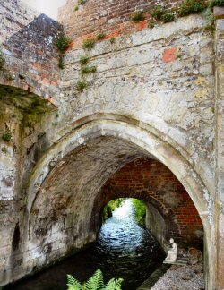 Another legacy of these early days is the medieval stone bridge still in place crossing the outflow from the pond and leading on to the dam and connecting with the old road from Winchester to Farnham. This was probably a later innovation to avoid the sharp descent down to the river and the climb up the opposite side to Old Alresford. It would have been a matter of practicality that a recently made up earthen structure would be difficult for users and likely to damage the structure of the dam itself when it was initially created. From the 1307/8 pipe rolls of the bishops Winchester it can be ascertained that money was spent on stone for the re-building of the bridge but this most likely replaced an earlier wooden bridge built to create the more level diversion over the dam a lot earlier in the 13th Century.
The Charter of King John to the Bishop of Winchester, Godfrey de Lucy, gave a market one day in every seven and to hold fairs on the feast of St. John the Baptist and the two following days. It is this Charter that lives on in the weekly Thursday market in Broad Street. This grant was confirmed by Edward II in the 1370s. Right from the beginning New Alresford was designed as a market town with the very wide ‘Broad’ street and the market house and shambles at the top.
The 14th Century was to experience one calamity after another. In the years 1315 to 1317 there was a great famine followed by the great plague in 1348/9. Alresford had to send two members to parliament in the 13th and 14th century but following the decline in the town's prosperity following the Black Death the town requested and was granted a release from this obligation.
16th, 17th & 18th Centuries
The Reformation seemed to have passed quietly in Alresford although the Tudor period was a time of high inflation. King John’s Charter, confirmed by Edward II, was reconfirmed and enhanced as shown by the copy granted to the 'Burrough' of New Alresford which appears in the Bishop's Register of 1572. Nine men of 'ye betar and more honest inhabitance of our town and Burrough', (one as Bailiff and the others as Burgesses) were charged with the organisation of the fairs and markets and the use of the income from these for the good of the town. This tax or ‘pavage’ as it was known lives on today in the form of market dues and fees collected by the Town Trustees, the successors to the Baliiff and Burgesses, for the use of Broad Street for fairs and markets. They did their work well. Courts were held, offences were dealt with, streets were paved, schools were financed, the Avenue was planted, the elderly were looked after, an organ was bought for the church and singing boys hired. It was about this time that the first use of the Town's Coat of Arms is recorded.
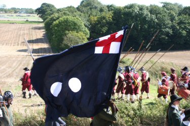 The Civil War touched Alresford briefly in the spring of 1644 when two royalist armies under Hopton tried to prevent the parliamentary army under Sir William Waller controlling access to Winchester and the region to the south and west of London. Early skirmishes took place around Bramdean Common and Cheriton Wood but the main conflict known as the Battle of Cheriton, took place in the valley between Tichborne Down, to the North, and Hinton Ampner, to the South. There is a commemorative plaque on the lane from Cheriton to Bishop's Sutton which overlooks the valley where the battle took place. The defeated Royalist Army made their retreat through Alresford in the evening of 29 March. Known as the Alresford fight the beaten Royalists retreated through the town setting fire to houses as they went. The battle was reputed to be the fourth largest, but more significantly it proved to be a turning point, of the war. Waller went on to take Winchester although the castle held out for some time leaving the city to be ransacked. The fires were extinguished by the Parliamentary troops.
Fires have been a part of life in Alresford over the centuries, some disastrous and others less so. The first serious fire was in 1440 but there were a number in the 17th century the most destructive being in 1689 which destroyed 117 houses in the town as well as the Church and Market House. This one resulted in a Royal Proclamation from William and Mary for a house-to-house collection to receive alms to be accounted for by the clergy. Most of the town was rebuilt by the end of the century. Alresford had another bad fire in 1736 which started in a brewery on the north side of West Street. None of the fires changed the street pattern of the town because a lot of the houses have cellars dating back to Norman times. When the town was rebuilt using brick and clay peg tiles or slate for roofing in the eighteenth century this saw an end to the serious fires and left Alresford much as you see it today - a Georgian town. A few buildings standing today escaped the fires notably on Mill Hill, The Dean and Pound Hill.
In 1696 a free grammar school was founded by Christopher Perin after his brother Henry bequeathed £420 in his will to build a school in West Street on the corner with The Dean. The building still stands but not as a school house.
The first Turnpikes Act was passed in 1663 but Alresford had to wait until an Act of Parliament in 1753 which permitted the building of the turnpike between Alton and Winchester. The turnpike goes through the town and continues through what becomes The Avenue bypassing Bighton, Medstead and the villages to the north of the River Itchen where the old London road ran. With the improvement in road surfaces, the turnpike on which the traffic paid tolls enabled services of coaches and freight wagons to run regularly between London and the Channel ports increasing the number and turnover of the inns in Alresford enormously.
The 19th Century
By 1800 Alresford had become a desirable place for “The Gentry” to live: established as a market town, it had several major coaching inns, good transport links, and many local tradesmen and retailers provided services and local employment in the area. The large houses and farmers also provided employment for labourers and domestic staff. Sheep Fairs and market days provided the major external sources of income to the town. The population was around 1100, only rising to 1300 over the hundred years – of these only 150 were typically quoted as in employment. Ropley, (in 1851) was quoted as having a population of a further 818 people.
These ‘gentry’ occupied the large houses in the town, and the surrounding mansions. The wars with France enabled naval officers to buy the local mansions, with their prize money: other ‘investors’ profited from commercial sea trading, maybe even from the slave trade. The retirement home of Admiral Lord Rodney (died 1792) had overlooked the Pond, and no doubt had attracted many other Naval officers, such as those in Hinton Ampner and Uppark House. The Alresford Cricket Club was one of the strongest in the country, regularly playing the Hambledon club: the Alresford cricket field was where the Golf Course is now located.
 The major passing trade for the town came from the daily coaches between Southampton and London, when passengers took a break in the Coaching Inns. These coaches also paid their road tolls at the local toll houses, one being sited on the Avenue. Jane Austen would have passed through Alresford regularly, travelling between Chawton and Winchester. Mary Mitford lived in Broad St as a child, maybe talking to the French officer prisoners of war, who were billeted here in an “Open” prison arrangement.
In 1831, for hygiene reasons, the sheep fairs were moved out of the town centre into a local field off Sun Lane. In 1837, 140,000 sheep were penned there – but by 1889 the average had fallen to 16,000. The ‘Drove’ roads and pathways around the town were created for ease of travel of these large flocks of sheep to the Alresford market. On the river, in the autumn, the Eel House caught large numbers of eels: many of these were transported to the London markets by horse and cart, and after 1865 by train. The preserved Eel House with its traps is one of the few in the country that are still standing – occasionally a single eel is seen. The sheep trade was served by the Fulling mill, cleaning the fleeces in the river water, but this ceased such work in the 1830s. Fly fishing for trout was also a popular sport on the River Alre.
The Dean School was established in 1840, and in 1858 the Alresford Market House Company built their market house, later to become the town community centre. 1865 saw the arrival of the railway, routed to the South of the town: this established quicker communication with London and Winchester/Southampton, for transporting local produce like watercress, eels, sheep, etc. In the late 1800s the ease of travel actually led to a decline in the numbers employed in the tailoring, dressmaking and service businesses, as people did their shopping further afield.
In 1869 the Bishop of Winchester gifted the land to the north and south of The Avenue to the Bailiff and Burgesses to be held and maintained by them for the recreational use of the residents of Old and New Alresford.
The end of the Century saw the town still prospering, serving the gentry and the local farm workers. The brewery in West Street prospered, and there were a large number of pubs in the village. Ginger beer was produced in the Pineapple House at the bottom of Broad Street, using water from a well – regular deliveries of their refilled glass bottles were made by horse and cart as far afield as Basingstoke. Further down Mill Hill various tanning businesses treating skins and hides were established.
In 1876 Mary Sumner, wife of the Rector of Old Alresford Church, started the Mother’s Union, campaigning for women and their rights, and in 1898 the nave of St John’s Church in New Alresford was totally rebuilt. At the end of the Century the guiding power behind the local community moved away from the local landowners and town businessmen, collectively represented by the Town Bailiff and Burgesses. By Act of Parliament in 1882 their revenue sources (from tolls, and market trader rents etc) and their powers were transferred to locally elected parish and district councils. Possibly the last major action by the Bailiff and Burgesses was to establish and build this Alresford Town Fire Station, completed in 1881! An odd clause in the 1882 Act allowed the retention of monies, land, property and rights of the former Bailiff & Burgesses to be transferred to a trust pending the formation of the Parish Council in 1894. New Alresford Town Trust was established in 1890 to administer these rights and assets and still does to this day.
The 20th Century
The new Century started with major changes to Government influence over local matters, for example with the introduction of elected local councils to replace the town Bailiffs, and the local education authorities taking control of what were then called national schools. The Dean school had been built in 1887, and served as the main national Primary and Junior school until around 1970. Another small private local school for children from age 5 to 16 was the Alresford Preparatory School, in Bay Tree Yard off West Street, which taught around 25 pupils: this also closed in 1968. Then the new school buildings, established at Sun Hill from 1968, took over.
Perins school, established in 1696 for 19 boy pupils at the bottom of West Street, had just become co-educational in 1899. Girls boarded in the original school building and the boys were housed in various buildings in Pound Hill. Perins then moved to the new building at the top of Pound Hill in 1909: by 1919 there were 146 pupils attending (currently the pupil numbers exceed 1150).
Alresford started the Century with a population of around 1300, but this showed little growth for 30 years, despite the building of new houses. The town in this period had many pubs, plus the large coaching inns, and several cafes - all serving visitors on horseback, on bicycles and subsequently in cars. All the town was north of the railway line: to the south of the line, Langtons Farm covered the land between Sun Lane and Jacklyn’s Lane, apart from some large houses like the Vicarage. Slowly this farm land was divided up, to include a plant nursery (now Nursery Road) and a chicken farm further up Jacklyn’s Lane, opposite the original town water supply tower (which was demolished in around 1953).
The 1930s saw many military training manoeuvres and camps locally, extending into WW2 when Northington and Morn Hill camps were major assembly points, and the Railway brought many Army tanks through Alresford and on to Morn Hill, Winchester and the southern ports. The US Army 14th Infantry Regiment, 9th Division (the US Army’s experts in amphibious warfare and landings) arrived in 1943: their headquarters were at 50 Broad Street, and the troops were camped where Valdean Park now stands, in the Dean. Famously their mascot, a dog named Hambone Junior, was accidentally killed (we think in a traffic accident), and was buried along the river walk. In 1934 Sir Francis Lindley bought the Weir House estate: his brother was CO of #4 Commando, and this led to several visits from Commandos en route to operations, and for R&R afterwards. Another visitor was Neville Chamberlain, early in WW2. A wartime visitor from the USAF was ‘Lucky Lady’, a Flying Fortress, whose crew were all lucky to parachute away from the final crash behind Alresford pond.
In 1950 the Weir House estate was broken up, and Mr Gush of Gush and Dent bought the Fulling Mill, establishing a nursery garden for charity alongside – this survived into the 1980s. In 1961 John Arlott adopted Alresford in semi-retirement, before moving to Alderney in 1981. The 1960 saw Alresford playing a significant part in the Portland spy ring scandal, as a “Dead letter drop” in the town’s public toilet. In 1964 a 25 year housing plan envisaged a target population of 4750, by major house building south of the railway line, between Jacklyn’s and Sun Lane. In 1981 the population was 4114 in Alresford, and 1432 in Ropley.
Industry was changing: the water mills had fallen into disuse by 1930, the Eel House by 1972. The 1972 Sheep fair had only 8000 animals for sale: the hurdle house was turned into a dwelling in the 1980s. British Rail closed its services down in 1973, but the line from Alresford to Alton was re-opened in 1977 as a heritage steam railway, with most engineering based at Ropley. New industries were established – in 1967 John and Margaret Jones established Alresford Crafts in the Town Mill on Mill Hill, making soft toys and dolls, which thrived and expanded into the Station Mill buildings, through to 1992. The next year Joram Agar established his oil industry instrumentation business in Prospect Road, which eventually moved to Kingsworthy in 1981. In 1974 Etchmasters established a business making etched copper engravings, featuring countryside themed pictures. In the centre of town there was significant growth in the number of wine bars and restaurants from the 1980s onwards, perhaps the most unusual being Rio Rio, a Mexican Restaurant on Pound Hill. Jane Bown, the staff portrait photographer with The Observer, famous for her pictures of Bertrand Russell, and HM The Queen aged 80, lived at 50 Broad Street, the original US Army HQ. Other well-known names of this period started life in Alresford - for example Derek Warwick, the racing driver, and Colin Firth, the actor.